Archaelogical sites and monuments

Akrotiri

Rhombus center

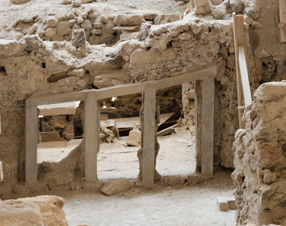
The pre-historic settlement of Akrotiri spreads over a small plain at the southern tip of Santorini. It consists of two natural harbours, the first harbour is noticeable at the end of the settlement towards the sea, and the second harbour has been covered with dust throughout the years. When weather permits, the volcanos of Psiloritis and the White Mountains are visible from Akrotiri. The proximity of Crete has played a major role in shaping Akrotiri.

The excavations of Akrotiri is one of the most important and well-preserved prehistoric settlements of the Aegean, with remarkable findings that contributed to the understanding of the Cycladic culture (from 4th to mid-second Millenium BC).


Archaelogical Sites and Monuments

The findings of ruins in Akrotiri were first mentioned in 1867 by the French scholars Gorceix and Mamet. While Zahn (1899) spotted and excavated the remains of same period at the East side of Akrotiri. Systematic excavations were carried out, by Professor Spyridon Marinato in 1962-1974.

He wanted to prove his theory, that the eruption of the volcano of Santorini was responsible for the collapse of the Minoan civilization. After his death, in 1976 the excavations resumed under the successful direction of Professor Christos Doumas and the Archaeological Society of Athens.

Akrotiri

Discoveries

Rhombus center

Approximately 11 acres have been investigated but this is estimated to only be 1/10 of the overall settlement surface. The search in this area and on the island is made significantly harder because of the volcanic residues, ash and pumice which have covered most surfaces. In some areas, the volcanic layers reach a height of 60 meters and have concealed all traces of habitation that preceded the eruption.

Due to soil erosion in Akrotiri caused by natural causes (water, air) the volcanic layers were significantly reduced and they brought to light archaeological relics that triggered the interest of researchers.

The city was destroyed by the great volcanic eruption mid- 17th Century BC and the first inhabitation dates from the late Neolithic times. Ceramics of this era were found in the southern part of the city but this design/style didn’t influence the island’s architecture.

A plethora of findings indicate the island being inhabited in the early Cycladic period (2800-1800 BC): Architectural relics, ceramics, clay figurines, stone tools, and also burials in forms of infusions inside chambers carved into the soft, volcanic natural rock. According to Duma, these chambers are identified with a cemetery of the Early Cycladic period. The corresponding settlement of which, only limited architectural remains have been discovered, as most were either destroyed by new inhabitants or are hidden under newer buildings.

During the Bronze Age (1800-1650 BC), the city was converted into a cosmopolitan harbour and turned into one of the main urban centres and ports of the Aegean.

The large extent of the settlement, the elaborate drainage system, the sophisticated multi-storeyed buildings with the magnificent wall-paintings, furniture and vessels, show its great development and prosperity. By the end of this period, Akrotiri had created a dense network of trade and exchanges both commercially and culturally with the rest of the Cyclades, mainland Greece, the Dodecanese, Crete, Cyprus, Egypt and Palestine.

Luxury and essential goods travelled to and from the abovementioned destinations. The city reached its peak in the middle of the 17th Century BC, just before its destruction from the volcanic eruption. Locals had acquired a lot of technical expertise and abilities that are reflected in the products that we see today from this era. They were expert sailors, fishermen, carpenters, builders, stonemasons, jewellers. During this period the art of wall painting flourished. Most of the buildings that have been excavated have wall paintings in either one or most of the rooms, mainly on the first floor. The largest wall paintings were found in the buildings of ‘Ksestis 3’ and ‘Ksestis 4’ (the excavations have still not been completed). Due to these findings, the ‘Kestis’ buildings are believed to have been administrative or religious centers.

Wall paintings play a major role for archaeological research as they depict practices and rituals of this era that would have been unknown to us otherwise. The absence of human remains from the city destroyed by the volcano, reveals that the inhabitants had been warned of the upcoming explosion by an earthquake. The cemetery of the city is yet to be found, we assume that in the midst of the Bronze Age (18th-19th Century BC) the cemetery was probably moved to the outskirts of the city which had been extensively expanded and the previous burial chambers were abandoned.

The findings did not confirm Marinatos’ hypothesis, that the volcanic eruption destroyed the Minoan civilization and that Akrotiri was a Minoan colony. Regardless of the significant Minoan influence that the population of Akrotiri received, they still preserved the Cycladic trait. The uncertainty of  the exact date of the volcanic eruption remains, the party that claims that the eruption took place between 1700 BC and 1619 BC and the other party claiming that it happened around 1500 BC.

Pyrgos – Kasteli

The Tower of Kallistis also known as ‘Pyrgos’ or ‘Kenourgiobourgo’, is the highest village on the island. It was one of the five castles of the island and it used to be the capital of Santorini after the abandonment of Skaros castle in Imerovigli. In the 18th Century under the Ottoman rule, the first school of Thira was founded in Pyrgos. It is now the church of the Holy Apostles (road towards Pyrgos/ Prophet Elias). The church’s temple is in the old teaching room, and it is still surrounded by ruins.

The castle endured damages at a very large scale in the 1956 earthquake. You could only enter the Castle from one entrance the ‘Kasteloporta’. On the top of the door there was a slit where they would throw hot oil on the invaders.

Below the castle there was a tunnel that served as an escape route to protect inhabitants. The Castle is surrounded by buildings of the ‘newer’ city, which was previously known as ‘Kseporto’. The square in front of the entrance of the castle was called ‘High Kafenes’ as this is where all the aristocracy would meet. Today there is a statue on this square of villagers during the period of  1912-1921.

In front of the entrance of the castle there is the church of ‘Agias Theodosias’, in close proximity, on a steep slope, opposite to Pyrgos is located the church of ‘Agios Georgios’ (built in 1754) which was also called ‘Katafiyo’, it means shelter and it was used for the inhabitants in hostile raids. In the square in front of the Castle is found the church of ‘Agios Nikolaos’, built in 1660.

On the West side of the castle is the ‘Theotokaki’ (Kimisis Theotokou), built in the 10th century. The icon was stolen in 1983. The church of the Virgin Mary is at the highest point of the castle. It was built during 1660-1661.

The Emporio Castle

Known as Emporio or Nimborio, is located on the south side of the island, at the foot of the mountain where the church of Elias the Prophet is. The origin of the name comes from the word ‘trade’, this is either because it is the location where all the trades took place, or because the commercial harbour of Elefsina was located there. Another theory is that the name comes from the French word ‘Bourg’ and ‘new’ (Bourg means medieval fortified villages). In the settlement you will find many ancient churches. At the entrance to the village, coming from Fira, there is the chapel of Agios Nikolaos of Marmari, which is an ancient burial monument of the 3rd Century BC. The church of the Virgin Mary (Panagia I Messani) of the 16th Century can also be found there, of which the wood-carved icon is from 1883. Lastly, the chapel of the ‘Metamorfosis tis Sotiros’ of the 19th Century.

The tower of Goulas, built in the 15th Century, is located on the northern part of the village. It is said that the tower had been built by the Monks of the Agiou Ioannou of Patmos Monastery, as there is a Chapel inside the Tower of Agios Christodoulou the founder of the Monastery of Patmos.

There was a tunnel linking the Tower with the Castle. The entrance to the castle exists today and locals refer to it as ‘Porta’. Surrounding the Tower, there is the temple of Agias Theodosia and opposite Goulas, there is the hill of Gavrilou where there are eight windmills built in the 19th Century. At the top of the hill there is also the Chapel of the Prophet Elia.

Fortress of Skaros

The oldest castle or otherwise known as ‘Epano Rocka’ (rock) was built during the Byzantine years by the Venetian Iakovos Varotsis, who was granted Santorini in 1207.

Skaros Castle used to serve as a home residence to Iakovos and his nobles. A whole settlement was built around the castle. At the entrance, there was a wooden bridge that is currently in ruins.

The abandonment of Skaros began in the early 17th Century, prompted by the volcanic eruption in 1650, and the earthquake of 1817. Skaros was the capital of the island until the 18th Century and its inhabitants are called Kastrini. Thomas Hope has a pencil drawing of old Skaro in his collection, which is located in the Benaki Museum.

Castle Oia Apanomerias

Oia was mentioned by travellers long before 1650. During the Frankish rule in the Aegean Sea, Oia was one of Santorini’s Castles. It flourished in the late 19th Century – early 20th Century, based on the local, commercial fleet and the growing transit trade of the Eastern Mediterranean especially between Russia and Alexandria. In 1890 it had a population of 2500 and 130 merchant ships. Oia, also referred to as ‘Kasteli of Agios Nikolaos’ dominated the northern end of the island, up until today, parts of the first residential parts of the settlement and the tower (Goulas) are well preserved.

Santorini Villas

Book your home now!

Rhombus center